United States Map and United States Satellite Images
Explore map of United States, United States map, cities map of United States, satellite images of United States, United States largest cities maps, political map of United States, driving directions, country atlas and traffic map.
United States Map FQA
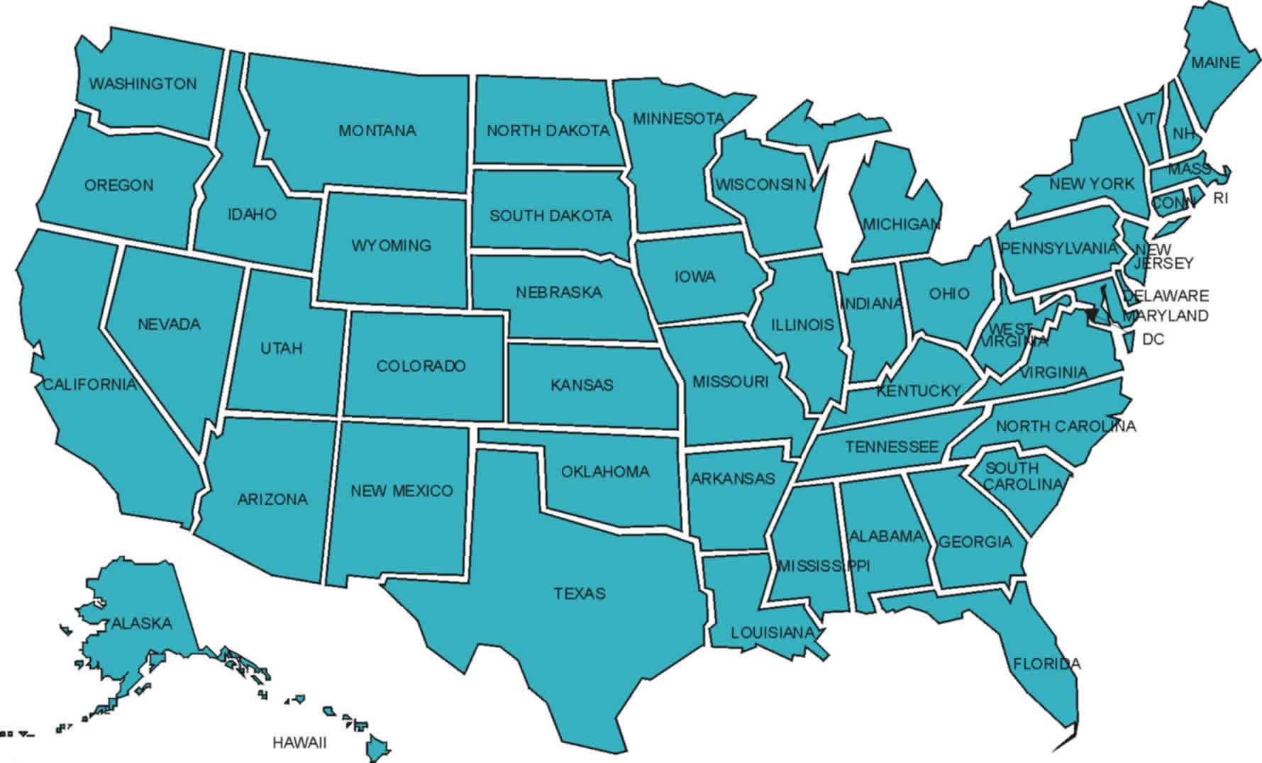
How many cities are in United States ?
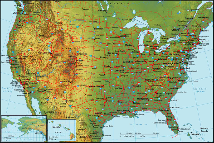
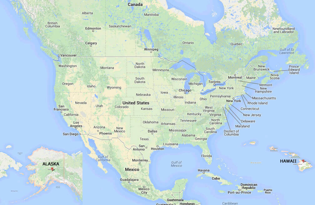
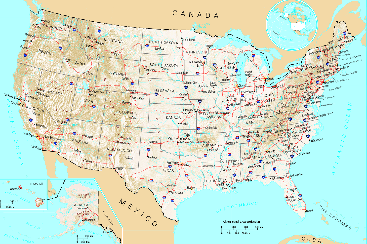
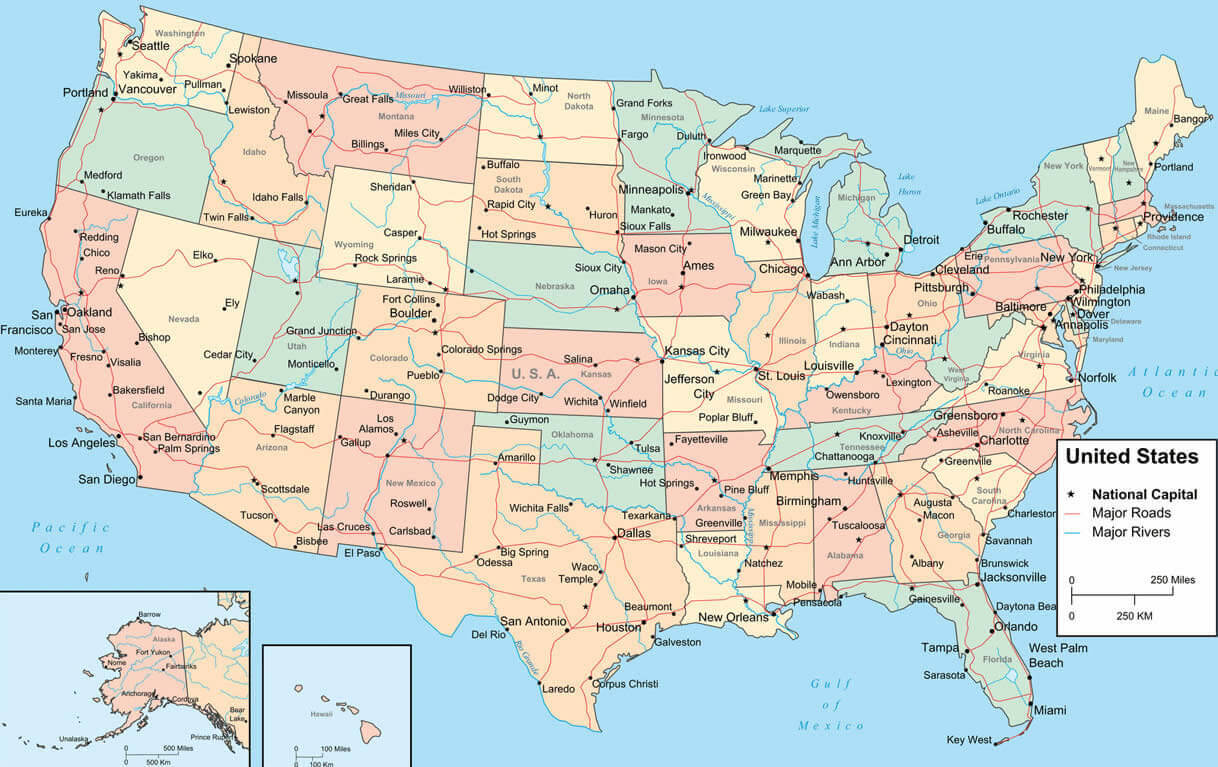
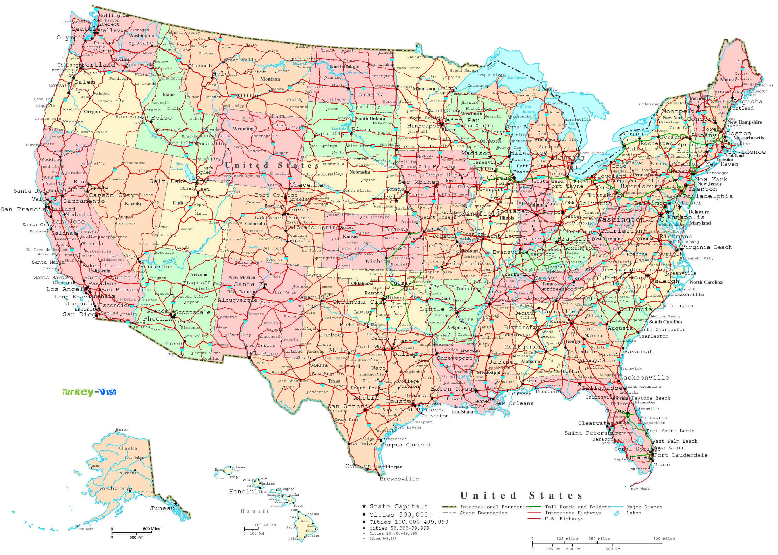
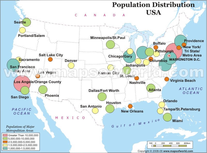
United States has more than 19,000 incorporated cities, towns, and villages. The largest by population are: New York City; Los Angeles; Chicago; Houston; Phoenix; Philadelphia; San Antonio; San Diego; Dallas; San Jose.What are the major geographical features of United States ?
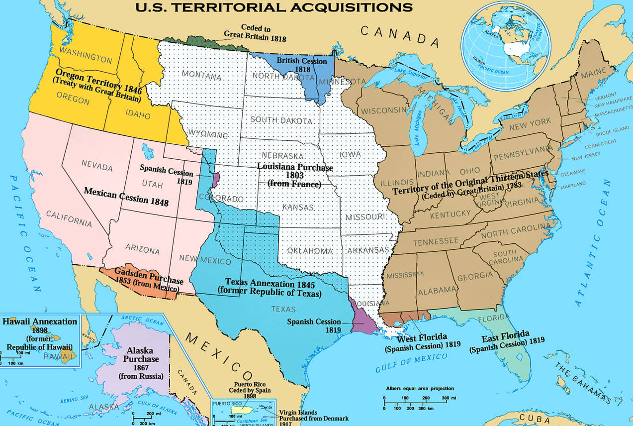
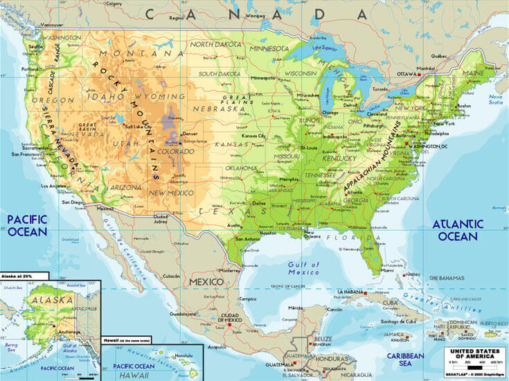
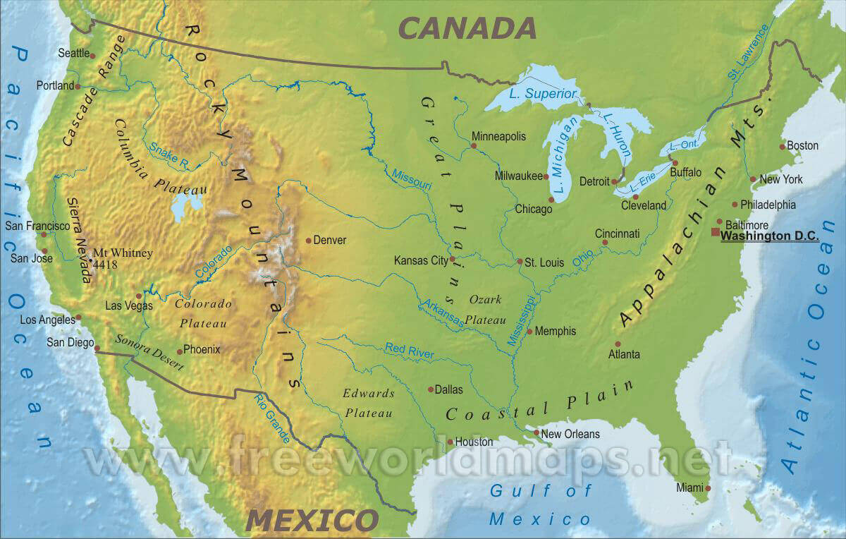
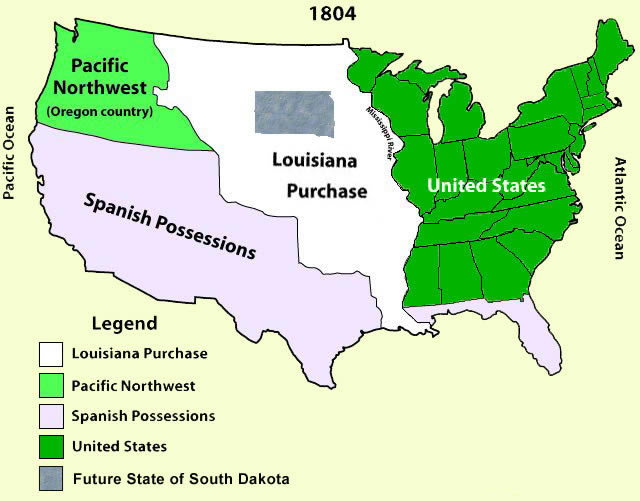
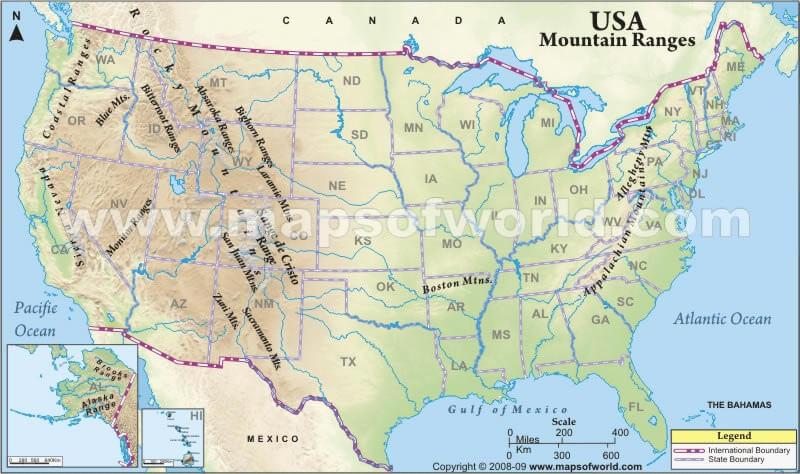
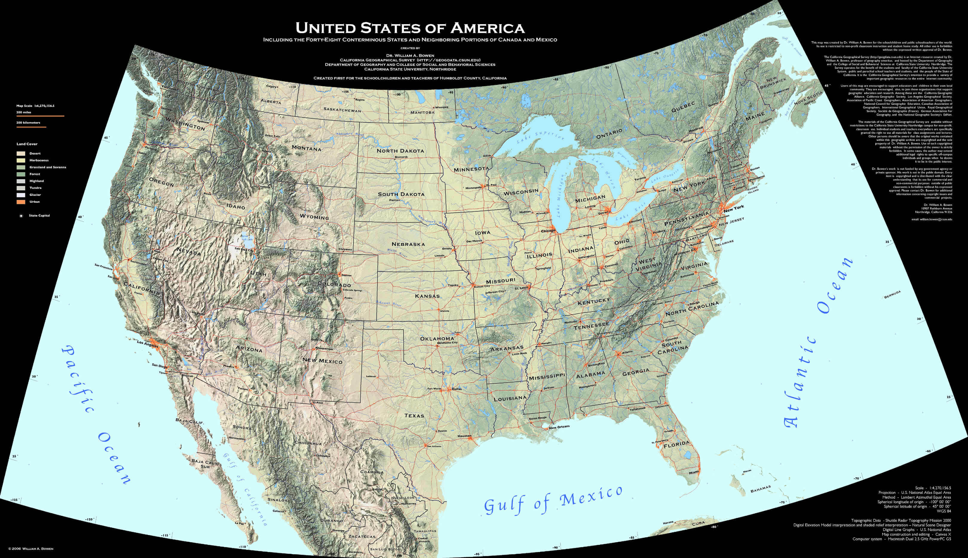
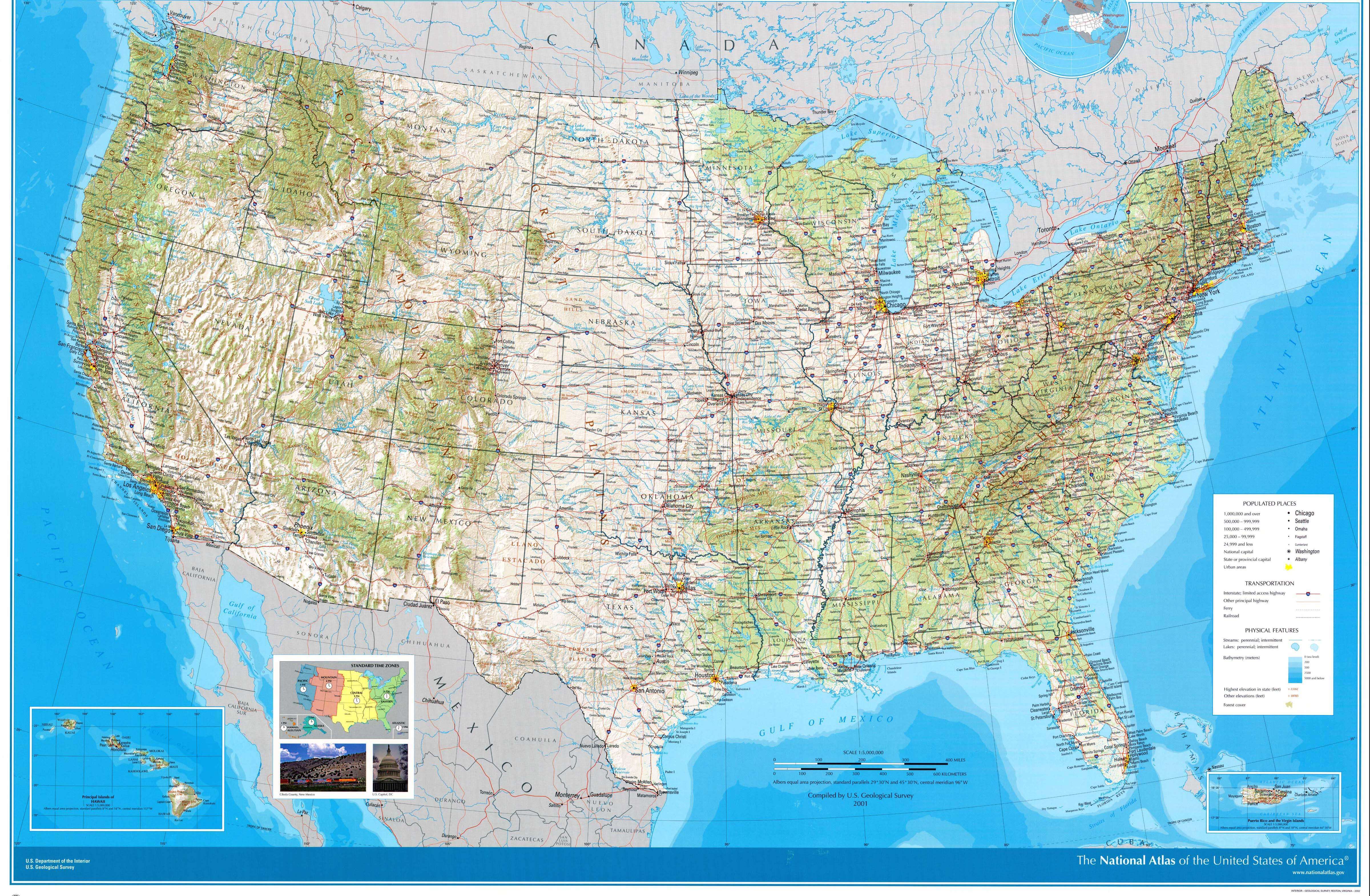
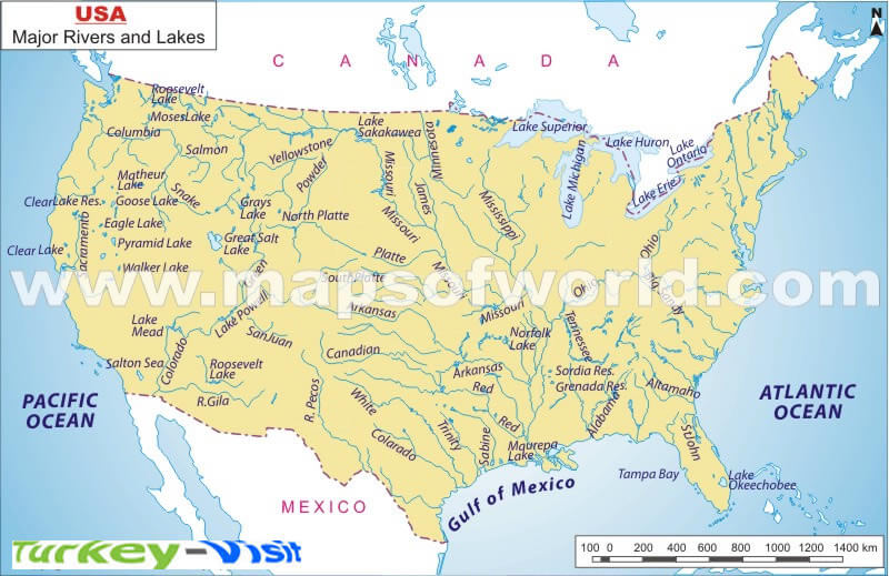
The United States has highly diverse geography, including the Appalachian and Rocky Mountains, the Great Plains, vast river systems such as the Mississippi and Missouri, deserts in the southwest, and long coastlines along the Atlantic and Pacific Oceans.US TERRITORIAL ACQUISITIONS MAP
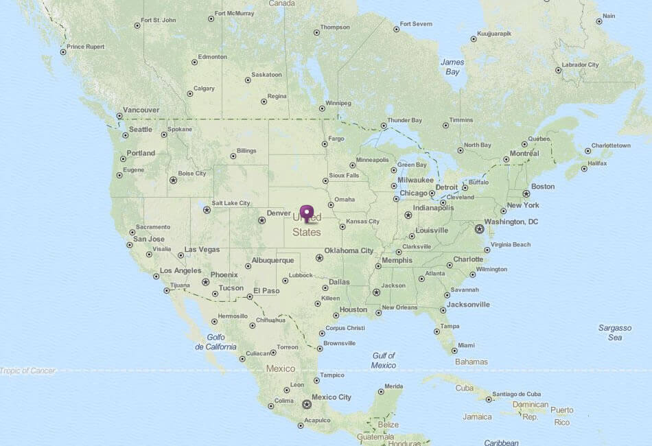
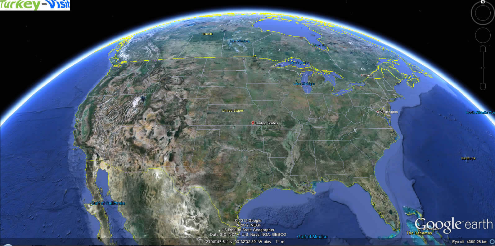
WHERE IS UNITED STATES IN THE WORLD
US TERRITORIAL ACQUISITIONS MAP
Can I download a high-resolution map of United States ?
Yes. Download high-resolution political and physical maps of United States for personal or educational use. Redistribution is subject to the terms of our license.
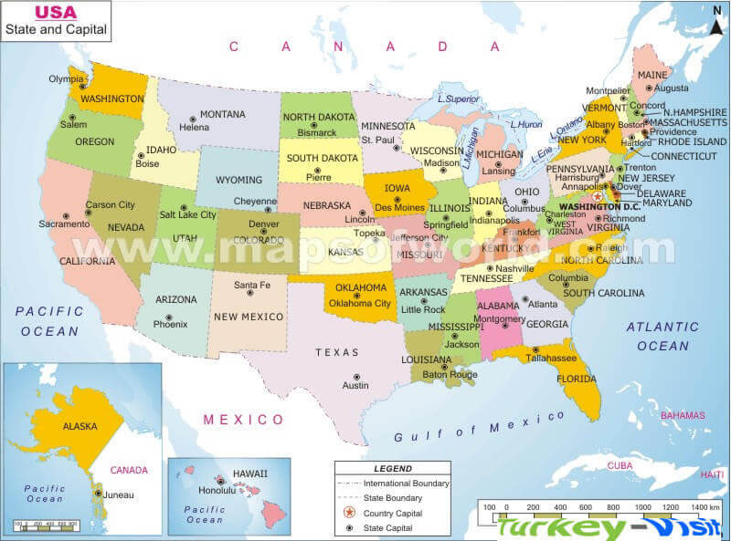
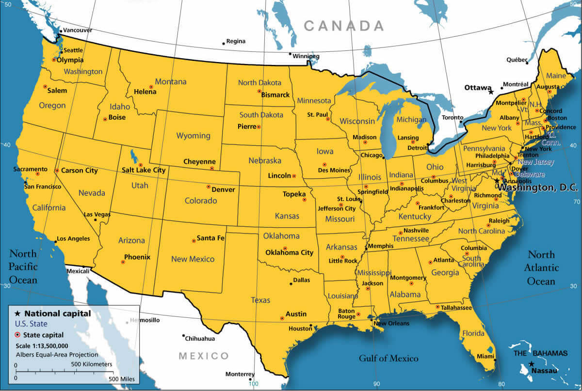
- Capital : Washington, D.C.
- Population : 315,276,000
- GDP : $15.6097 trillion (1st)
- Per Capita : $49,601 (15th)
- Calling Code : +1
- Jobless Rate : 7.90%
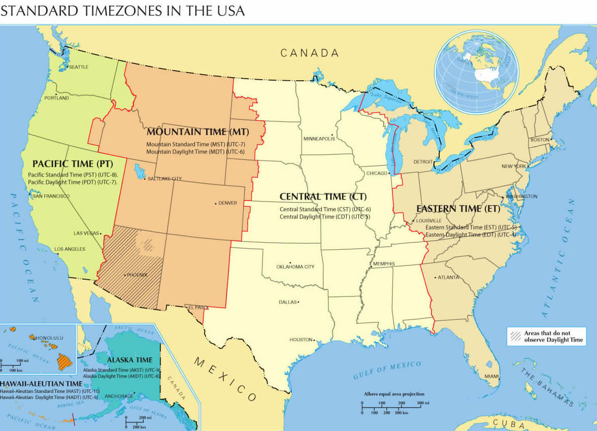
- Time Zone : -5 -10
For more about United States >>
A Collection of United States Maps and United States Satellite Images
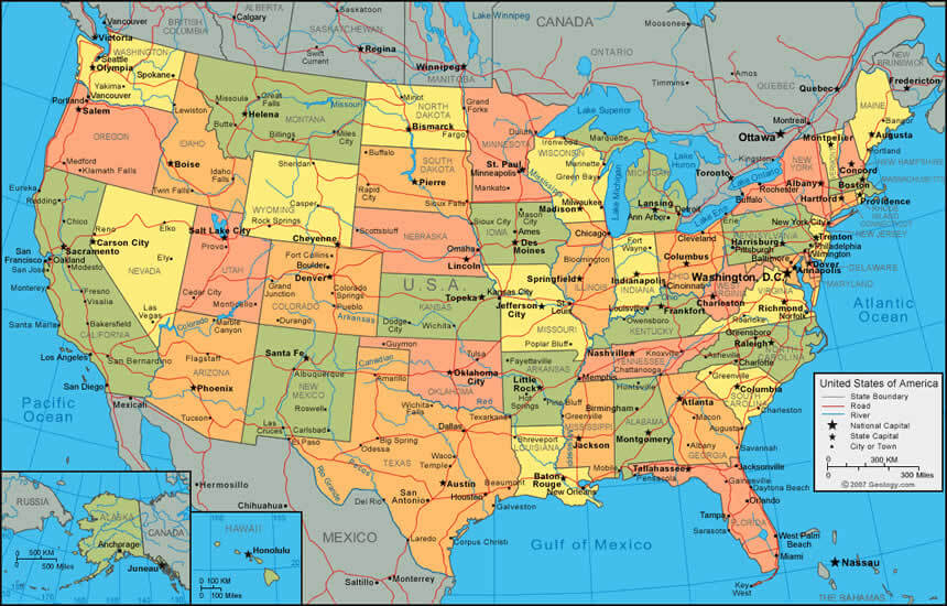
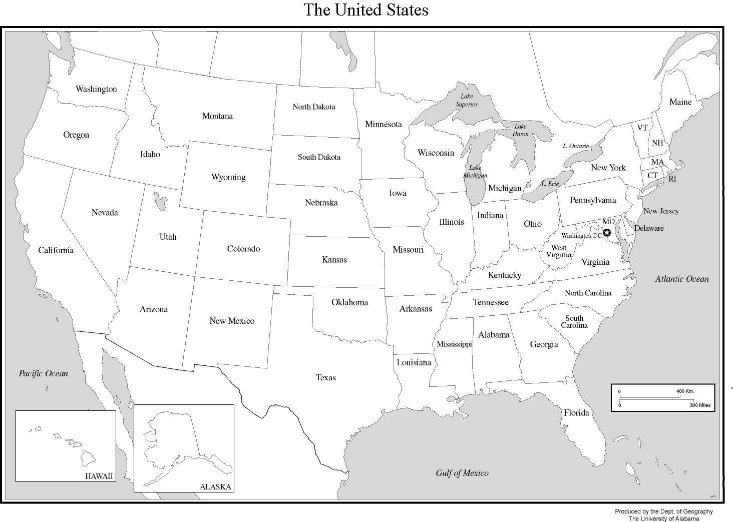
MAP OF USA
WHERE IS UNITED STATES IN THE WORLD
US TERRITORIAL ACQUISITIONS MAP
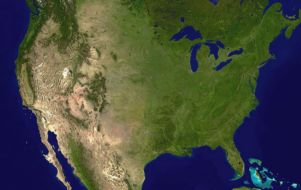
UNITED STATES SATELLITE IMAGE MAP
US ANCESTRIES BY COUNTY CENSUS MAP 2000
POLITICAL SYSTEM MAP OF THE UNITED STATES
USA FEDERAL DEBT HELD 1790 2013
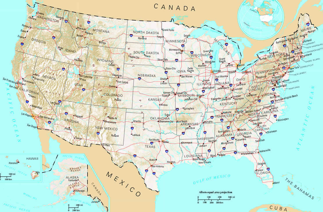
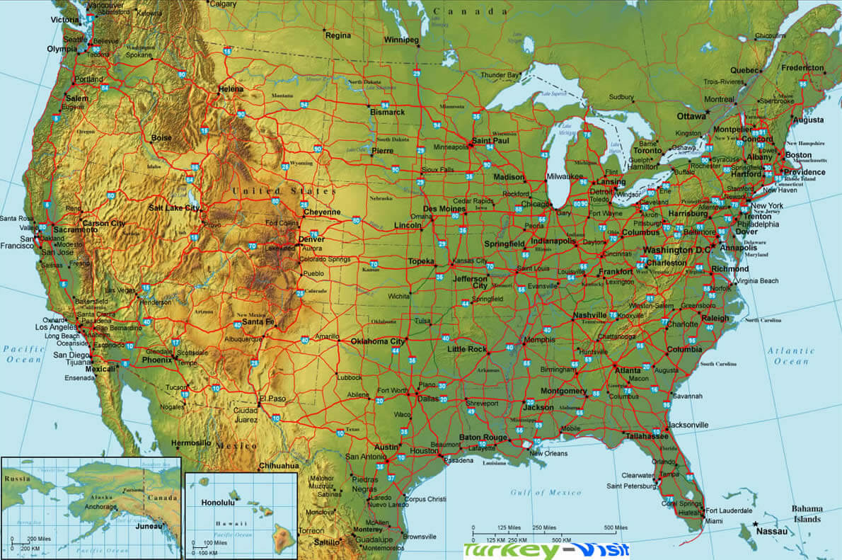
US INTERSTATE HIGHWAY SYSTEM MAP
US INSULAR AREAS MAP
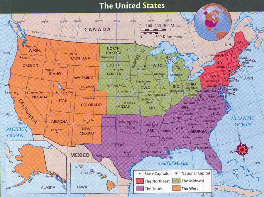
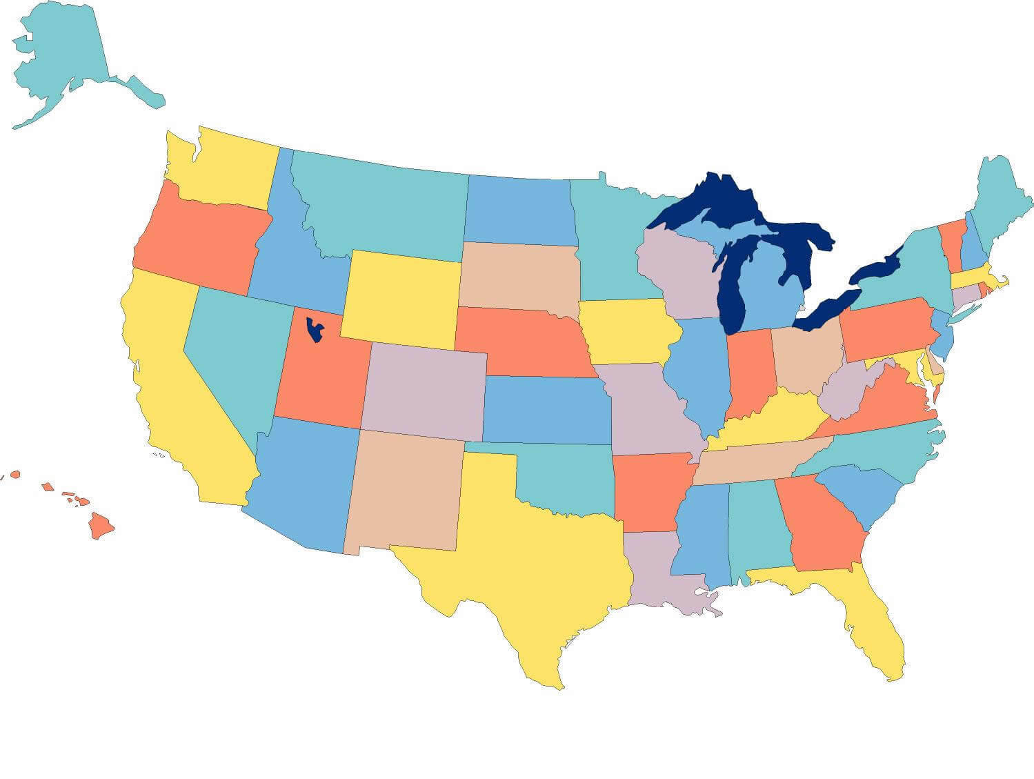
US POLITICAL DIVISIONS MAP
USA RELIGIOUS 2014 LANGUAGES SPOKEN 2010
MAP OF UNITED STATES
MAP OF UNITED STATES
MAP OF UNITED STATES
MAP OF UNITED STATES
MAP OF USA
MAP OF USA B
MAP OF USA CITIES
MAP OF USA WALL
MAP OF USA WALL B
MAPS OF UNITED STATES
MAPS OF UNITED STATES
MAPS OF USA
PHYSICAL MAP OF UNITED STATES
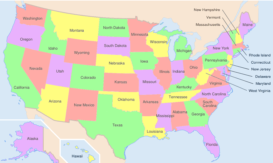
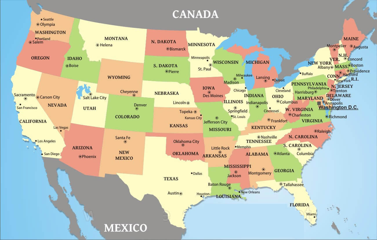
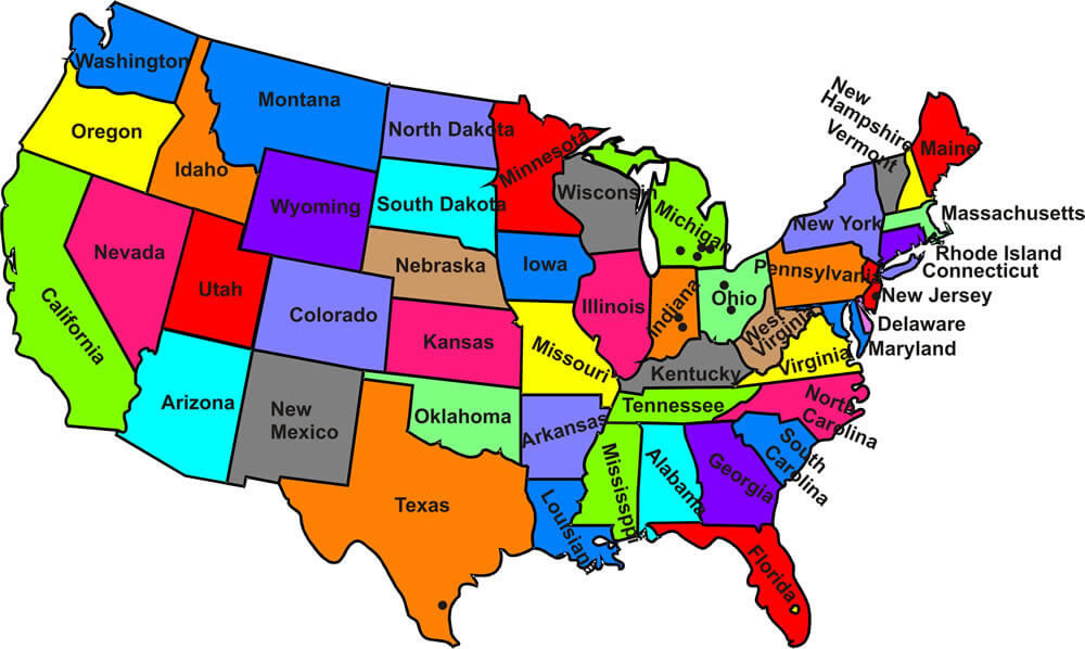
STATES MAP USA
UNITED STATES HIGHWAY MAP
UNITED STATES MAP PHYSICAL
UNITED STATES MAP PHYSICAL B
UNITED STATES MAP
UNITED STATES MAP
UNITED STATES MAPS
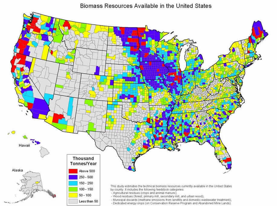
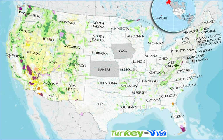
UNITED STATES BIOMASS MAP
UNITED STATES CATHOLIC MAP
UNITED STATES CITIES MAP
UNITED STATES CITIES MAP B
UNITED STATES ELECTORAL VOTES
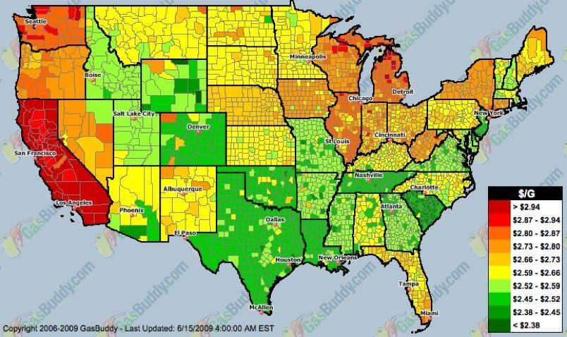
UNITED STATES GAS PRICES MAP
UNITED STATES INCOME MAP
UNITED STATES INCOME MAP B
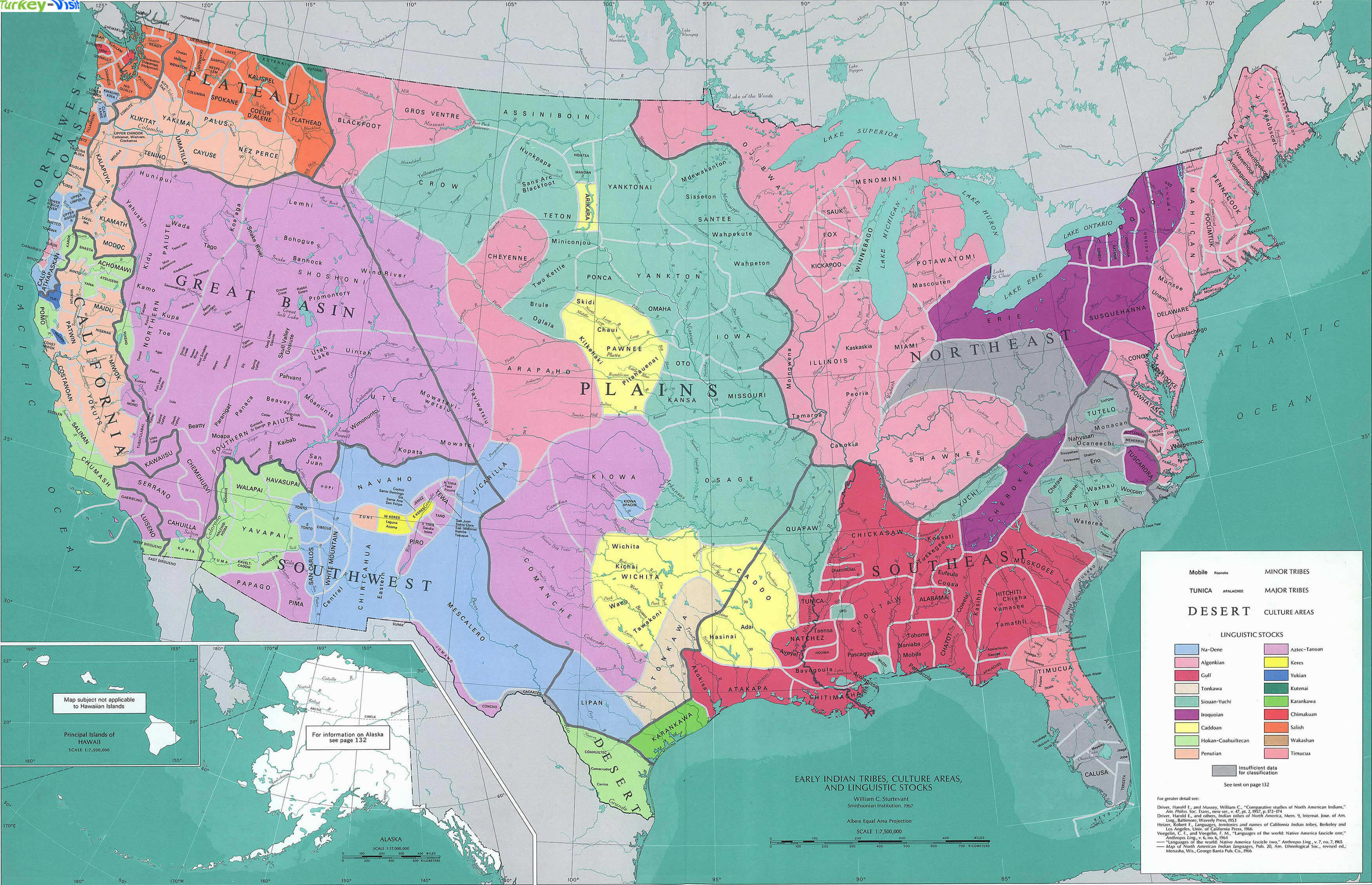
UNITED STATES INDIAN TRIBES MAP
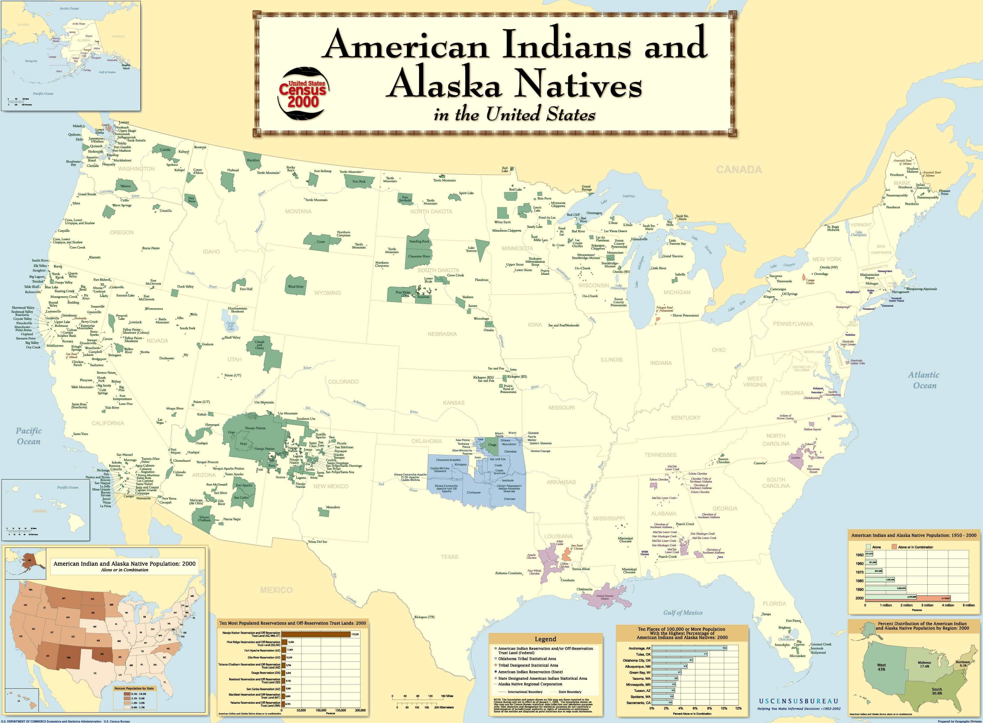
UNITED STATES INDIAN TRIBES MAP B
UNITED STATES MAP
UNITED STATES MAP
UNITED STATES MAP 1804
UNITED STATES MAP EMPTY
UNITED STATES MAP PHYSICAL
UNITED STATES MAPS
UNITED STATES MOUNTAIN MAP
UNITED STATES OF AMERICA MAP
UNITED STATES OIL SHALE MAP
UNITED STATES PHYSICAL MAP
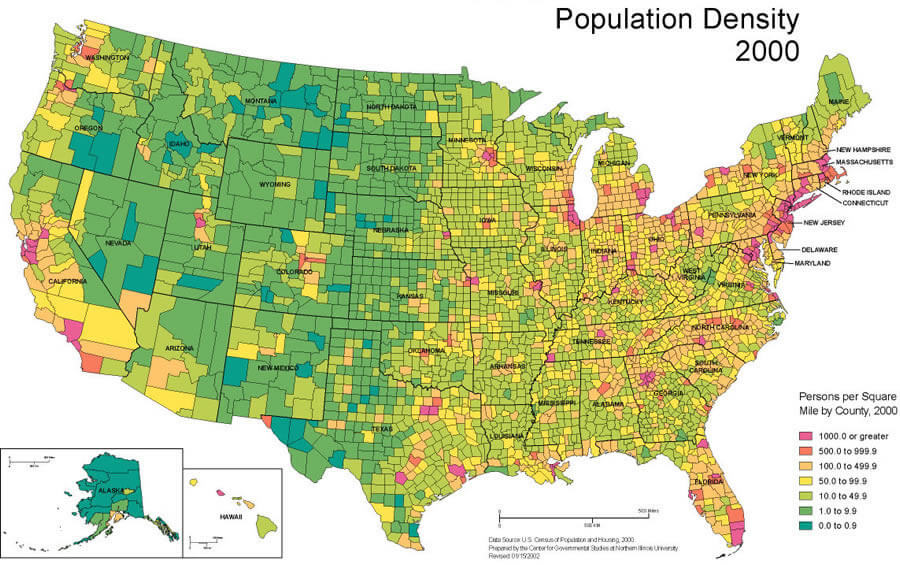
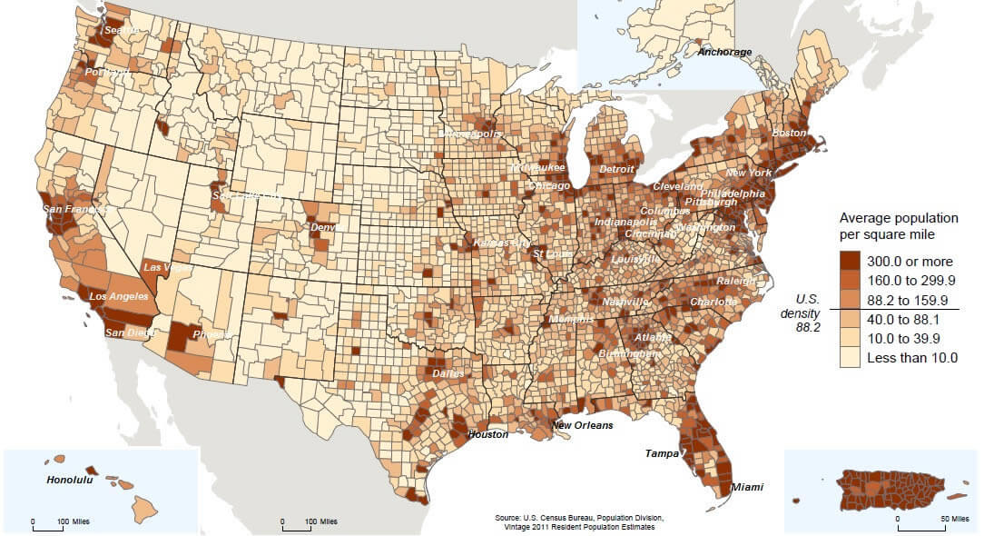
UNITED STATES POPULATION DENSITY MAP
UNITED STATES POPULATION MAP
UNITED STATES PRECIPITATION MAP
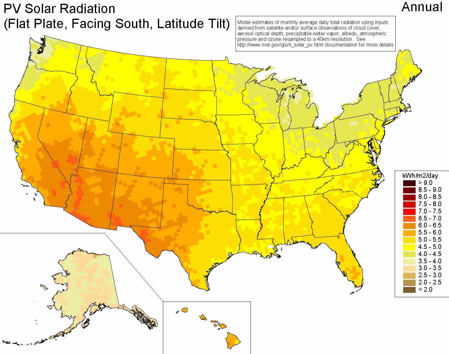
UNITED STATES RENEWABLE RESOURCES
UNITED STATES TIMEZONES
UNITED STATES WALL MAP
UNITED STATES WALL MAP B
USA MAP
USA POPULATION MAP
USA STATES MAP
USA H1N1 MAP
USA MAP
USA MAP

USA MAP EMPTY
USA MAPS
USA PHYSICAL MAP
USA RELIGION MAP
USA RIVER MAP
USA SOLAR MAP
USA STATES MAP WHITE
USA STATES REGIONS MAP
USA WIND MAP
USAMAP
UNITED STATES EARTH MAP
Largest Cities' Map of United States
New York City Map Los Angeles Map Chicago Map Brooklyn Map Houston Map Philadelphia Map Manhattan Map Phoenix Map San Antonio Map San Diego Map Dallas Map San Jose Map Jacksonville Map Indianapolis Map San Francisco Map Austin Map Columbus Map Fort Worth Map Charlotte Map Detroit Map El Paso Map Memphis Map Baltimore Map Boston Map Seattle Map Nashville Map Denver Map Louisville Map Milwaukee Map Portland Map Las Vegas Map Oklahoma City Map Albuquerque Map Tucson Map Fresno Map Sacramento Map Long Beach Map Kansas City Map Mesa Map Virginia Beach Map Atlanta Map Colorado Springs Map Omaha Map Raleigh Map Miami Map Cleveland Map Tulsa Map Oakland Map Honolulu Map Minneapolis Map Wichita Map Arlington Map Bakersfield Map New Orleans Map Anaheim Map Tampa Map Aurora Map Santa Ana Map St. Louis Map Pittsburgh Map Corpus Christi Map Riverside Map Cincinnati Map Lexington Fayette Map Anchorage Map Stockton Map Toledo Map St. Paul Map Newark Map Greensboro Map Buffalo Map Plano Map Lincoln Map Henderson Map Fort Wayne Map Jersey City Map St. Petersburg Map Chualar Map Norfolk Map Orlando Map Chandler Map Laredo Map Madison Map Winston Salem Map Lubbock Map Baton Rouge Map Durham Map Garland Map Glendale Map Reno Map Hialeah Map Paradise Map Chesapeake Map Scottsdale Map North Las Vegas Map Irving Map Fremont Map Irvine Map Birmingham Map Rochester Map San Bernardino Map Spokane Map Gilbert Map Arlington Map Montgomery Map Boise City Map Richmond Map Des Moines Map Modesto Map Fayetteville Map Shreveport Map Akron Map Tacoma Map Aurora Map Oxnard Map Fontana Map Yonkers Map Augusta Map Mobile Map Little Rock Map Hughes Map Moreno Valley Map Glendale Map Amarillo Map Huntington Beach Map Columbus Map Sunrise Manor Map Grand Rapids Map Salt Lake City Map Tallahassee Map Worcester Map Newport News Map Huntsville Map Knoxville Map Spring Valley Map Providence Map Santa Clarita Map Grand Prairie Map Brownsville Map Jackson Map Overland Park Map Garden Grove Map Santa Rosa Map Chattanooga Map Oceanside Map Fort Lauderdale Map Rancho Cucamonga Map Port St. Lucie Map Ontario Map Vancouver Map Tempe Map Springfield Map Lancaster Map Eugene Map Pembroke Pines Map Salem Map Cape Coral Map Peoria Map Sioux Falls Map Springfield Map Elk Grove Map Rockford Map Palmdale Map Corning Map Salinas Map Pomona Map Pasadena Map Joliet Map Paterson Map Kansas City Map Torrance Map Syracuse Map Bridgeport Map Hayward Map Fort Collins Map Escondido Map Lakewood Map Naperville Map Dayton Map Hollywood Map Sunnyvale Map Alexandria Map Mesquite Map Metairie Map Hampton Map Pasadena Map Orange Map Savannah Map Cary Map Fullerton Map Warren Map Clarksville Map McKinney Map McAllen Map New Haven Map Sterling Heights Map West Valley City Map Columbia Map Killeen Map Topeka Map Thousand Oaks Map East La Mirada Map Cedar Rapids Map Olathe Map Elizabeth Map Waco Map Hartford Map Visalia Map Gainesville Map Simi Valley Map Stamford Map Bellevue Map Compton Map Miramar Map Coral Springs Map Lafayette Map Charleston Map Carrollton Map Roseville Map Thornton Map Beaumont Map Allentown Map Surprise Map Evansville Map Abilene Map Frisco Map Independence Map Santa Clara Map Springfield Map Vallejo Map Victorville Map Athens Map Peoria Map Lansing Map Ann Arbor Map El Granada Map Denton Map Benton Map Provo Map Douglas City Map Midland Map Norman Map Waterbury Map Corte Madera Map Inglewood Map Manchester Map Murfreesboro Map Columbia Map Enterprise Map Elgin Map Clearwater Map Miami Gardens Map Rochester Map Pueblo Map Lowell Map Wilmington Map San Buenaventura (Ventura) Map Arvada Map Westminster Map West Covina Map Gresham Map Fargo Map Norwalk Map Caribou Map Fairfield Map Cambridge Map Wichita Falls Map High Point Map Billings Map Green Bay Map West Jordan Map Richmond Map Brandon Map Murrieta Map Buena Vista Map Palm Bay Map Everett Map Flint Map Antelope Map Erie Map South Bend Map Cypress Map Centennial Map Temecula Map Edison Township Map Odessa Map West Palm Beach Map Round Rock Map Pompano Beach Map Davenport Map Columbia Map Santa Maria Map Edwards AFB Map Richardson Map Kenosha Map Rialto Map Broken Arrow Map Spring Hill Map Dearborn Map Albany Map Las Cruces Map North Charleston Map Lakeland Map Boulder Map San Mateo Map Roanoke Map Livonia Map Tyler Map Lawton Map Clinton Township Map Highlands Ranch Map Comptche Map Cloverdale Map Portsmouth Map Lewisville Map New Bedford Map South Gate Map College Station Map Sandy Springs Map The Woodlands Map Vista Map Brockton Map Mission Viejo Map San Angelo Map Yuma Map Greeley Map Vacaville Map Kent Map Quincy Map Arcata Map Davie Map Carrick Map Hillsboro Map Lee's Summit Map Macon Map Pearland Map Yakima Map Renton Map Tuscaloosa Map Lynn Map Sparks Map Hesperia Map Canton Township Map Redding Map Beaverton Map Spokane Valley Map Santa Monica Map Westminster Map Federal Way Map Waukegan Map Fall River Map Toms River Map Santa Barbara Map Roswell Map Orem Map Reading Map Miami Beach Map Lawrence Map Rio Rancho Map Sandy Map Lehigh Acres Map Nashua Map Germantown Map Longmont Map Duluth Map Huslia Map Fort Smith Map Chester Map Norwalk Map Whittier Map Newport Beach Map Deltona Map Newton Map Plantation Map San Leandro Map Trenton Map Suffolk Map Greenville Map Sunrise Map Boca Raton Map Hawthorne Map Allen Map Clifton Map Westland Map Cicero Map San Marcos Map League City Map Asheville Map Citrus Map Alhambra Map Tracy Map Bloomington Map Ogden Map Sioux City Map Warwick Map Hoover Map Parma Map Nampa Map Edmond Map San Tan Valley Map Champaign Map Troy Map Livermore Map Danbury Map Bellingham Map Hammond Map Buellton Map Longview Map Bloomington Map Cranston Map Gary Map Lakewood Map Farmington Hills Map O'Fallon Map Carmel Map Concord Map Merced Map Racine Map Sugar Land Map Hemet Map Town n Country Map Alafaya Map Chinese Camp Map Largo Map Menifee Map Albany Map Camden Map Lake Forest Map Edinburg Map New Rochelle Map Mission Map Napa Map Redwood City Map Fishers Map St. Joseph Map Johns Creek Map Bend Map Bella Vista Map Bloomington Map Lawrence Map Avondale Map Bryan Map Decatur Map Scranton Map Melbourne Map Indio Map Brooklyn Park Map Somerville Map Lynchburg Map Tustin Map Baker Map Kendall Map Palm Coast Map Cheektowaga Map Arlington Heights Map Meridian Map Deerfield Beach Map Bethlehem Map Medford Map Chino Map Evanston Map Kalamazoo Map Schaumburg Map Mountain View Map Kennewick Map Alameda Map Shelby Township Map Upland Map Fayetteville Map Hydaburg Map Bolingbrook Map New Britain Map Canton Map St. George Map Appleton Map Folsom Map San Ramon Map Wyoming Map Lake Charles Map Baytown Map Gastonia Map Southfield Map Waterford Township Map Silver Spring Map Pawtucket Map Centreville Map Riverview Map Rochester Hills Map Wilmington Map Waukesha Map Plymouth Map Pharr Map Pleasanton Map Auburn Map Jacksonville Map Muncie Map Hyder Map Springdale Map Passaic Map Lynwood Map Union City Map Anza Map Redlands Map Palatine Map Turlock Map Waterloo Map Perris Map Framingham Map Boynton Beach Map Rapid City Map Santa Fe Map Iowa City Map Mount Pleasant Map Gulfport Map Waldorf Map Glen Burnie Map Missouri City Map Layton Map Mount Vernon Map Igiugig Map Jonesboro Map Lafayette Map Manteca Map Youngstown Map Lauderhill Map Loveland Map Casas Adobes Map Milpitas Map Missoula Map Redondo Beach Map Kenner Map Warner Robins Map Union City Map Portland Map Rock Hill Map Schenectady Map Temple Map Oshkosh Map Dale City Map Eau Claire Map Flagstaff Map Atascocita Map St. Cloud Map Ellicott City Map St. Charles Map Davenport Map Dothan Map Weston Map Goodyear Map Frederick Map Jackson Map Camanche Village Map Yuba City Map Harlingen Map Skokie Map Rancho Cordova Map West Bloomfield Township Map Flower Mound Map Palo Alto Map East Orange Map Yorba Linda Map Eagan Map Walnut Creek Map Lorain Map South San Francisco Map Dundalk Map Janesville Map San Clemente Map Florence Graham Map North Richland Hills Map West Hartford Map Pittsburg Map Johnson City Map Taylor Map Bayonne Map Laguna Niguel Map Pico Rivera Map Victoria Map Montebello Map Franklin Map Hamilton Map Iliamna Map North Little Rock Map Fort Myers Map Utica Map Council Bluffs Map Shawnee Map Millcreek Map Lodi Map Woodbury Map Carmet Map Maple Grove Map Coon Rapids Map Madera Map Castle Hill Map Bossier City Map Bismarck Map Rockville Map Daytona Beach Map Haverhill Map Meriden Map Bethesda Map Eden Prairie Map Terre Haute Map Vineland Map Brentwood Map Waltham Map Springfield Map Delray Beach Map Homestead Map Bristol Map Tamarac Map West Allis Map Burnsville Map Monterey Park Map La Habra Map Pine Hills Map Marysville Map Santa Cruz Map Gaithersburg Map Pasco Map Fountainebleau Map St. Clair Shores Map Kissimmee Map Encinitas Map Pontiac Map Cheyenne Map Malden Map Springfield Map Lancaster Map Tulare Map Ames Map Conway Map Ivanof Bay Map Gardena Map North Miami Map Brookline Map Taylorsville Map National City Map Grand Junction Map Great Falls Map Greenville Map Reston Map Des Plaines Map Culver City Map Lakewood Map Tonawanda Map Huntington Park Map Bowling Green Map Petaluma Map Dearborn Heights Map New Braunfels Map San Rafael Map Dubuque Map Alpharetta Map Rocky Mount Map Palm Harbor Map North Port Map Owensboro Map Royal Oak Map Chapel Hill Map Blaine Map South Whittier Map Perris Camp Map La Mesa Map Rocklin Map White Plains Map Idaho Falls Map Orland Park Map Tinley Park Map Oak Lawn Map Berwyn Map Union Township Map West Des Moines Map Marietta Map Wellington Map Mansfield Map Arbuckle Map Ocala Map Conroe Map Rowlett Map Medford Map Kettering Map Kendale Lakes Map Anderson Map Port Orange Map Rogers Map Juneau Map Lakeville Map Broomfield Map Taunton Map Decatur Map West Haven Map Diablo Grande Map Woodland Map Casper Map Fountain Valley Map Chicopee Map Carson City Map Tamiami Map Novi Map Towson Map New Brunswick Map Jupiter Map Moore Map Bowie Map Wayne Township Map Bartlett Map Elyria Map Valdosta Map Corvallis Map Port Charlotte Map Midwest City Map Spring Map Pocatello Map Mount Prospect Map Porterville Map Redmond Map Paramount Map Hacienda Heights Map Hanford Map Irvington Township Map Hempstead Map Port Arthur Map Lakewood Map Rosemead Map Weymouth Town Map Easton Map Sanford Map Santee Map Auburn Map Margate Map Poinciana Map Highland Map Del Rio Map Shoreline Map Levittown Map Coconut Creek Map Wheaton Map Grand Forks Map Blue Springs Map St. Peters Map Lake Havasu City Map Normal Map South Hill Map Battle Creek Map Manhattan Map Florissant Map Coloma Map Lakewood Map Noblesville Map Pensacola Map Sarasota Map Novato Map Hoffman Estates Map Levittown Map Oak Park Map Lake Elsinore Map Revere Map Irondequoit Map Saginaw Map Brea Map The Villages Map Charleston Map Stratford Map Hendersonville Map Yucaipa Map La Crosse Map Euless Map Smyrna Map Milford Map East Hartford Map Peabody Map Castroville Map Watsonville Map The Hammocks Map Elkhart Map Buckeye Map Perth Amboy Map Catalina Foothills Map Placentia Map South Jordan Map Niagara Falls Map Albany Map Joplin Map Bellevue Map Troy Map Glendora Map Hoboken Map Cuyahoga Falls Map Harrisburg Map Aloha Map Enid Map Sheboygan Map Huntington Map Pine Bluff Map Kachemak Map Southaven Map Euclid Map Monroe Map Aspen Hill Map Middletown Map Grand Island Map Roswell Map Kingsport Map Lenexa Map Logan Map Tigard Map Mansfield Map Alexandria Map Salina Map Pearl City Map Newark Map Chesterfield Map Lehi Map Binghamton Map East Providence Map Murray Map Wauwatosa Map Altoona Map Dunwoody Map Caldwell Map Hattiesburg Map Farmington Map Stillwater Map Ankeny Map West Seneca Map Coeur d'Alene Map Twin Falls Map Biloxi Map Collierville Map York Map Summerville Map Hilo Map West Babylon Map Jefferson City Map Fond du Lac Map Madison Map Freeport Map Concord Map Burlington Map Penn Hills Township Map Hutchinson Map State College Map Hicksville Map Wilkes Barre Map Cleveland Map Woonsocket Map Meridian Map South Valley Map Minot Map Covington Map Sumter Map North Atlanta Map Smyrna Map Urbandale Map Florence Map Cedar Falls Map Muskogee Map Coram Map Kailua Map Whitney Map Waipahu Map East Meadow Map Clovis Map Valley Stream Map Bozeman Map Mableton Map Hilton Head Island Map Florence Map Spartanburg Map Gadsden Map Lake Oswego Map Brighton Map Lewiston Map Keizer Map Pahrump Map Rome Map Dover Map Goose Creek Map Martinez Map Bartlesville Map Kake Map Bentonville Map Leavenworth Map Hot Springs Map Cumberland Map Marion Map Kaneohe Map Tupelo Map Greenville Map Norristown Map Hobbs Map Vestavia Hills Map Chester Map Prattville Map Houma Map Butte Silver Bow Map Olive Branch Map Daly City Map Bettendorf Map Marrero Map Mount Lebanon Township Map Bangor Map Phenix City Map Bethel Park Map North Providence Town Map Lewiston Map Leawood Map Hopkinsville Map Radnor Township Map Parkersburg Map Newark Map Richmond Map Laramie Map Kearney Map Benton Map New Iberia Map Alamogordo Map Dover Map Florence Map Texarkana Map Laplace Map Shawnee Map Rochester Map Morgantown Map Aiken Map Sherwood Map Williamsport Map West Warwick Town Map Georgetown Map Gillette Map Owasso Map Henderson Map Elizabethtown Map Wheeling Map Monroeville Map Jacksonville Map Helena Map Drexel Hill Map Nicholasville Map Winchester Map Mililani Town Map Post Falls Map Dodge City Map Plum Map Myrtle Beach Map Slidell Map Easton Map Anderson Map Garden City Map Jeffersontown Map Fremont Map Kahului Map Carlsbad Map Aberdeen Map Horn Lake Map West Fargo Map Frankfort Map Rexburg Map Ponca City Map Clinton Map Pearl Map Paducah Map South Portland Map Hastings Map North Platte Map Newport Map Norfolk Map Madison Map Summerlin South Map Ridgeland Map Starkville Map Moscow Map Keene Map Auburn Map Rock Springs Map Bristol Town Map Ewa Gentry Map Columbus Map Brookings Map Derry Map Gallup Map Watertown Map Biddeford Map Mililani Mauka Map Kihei Map Portsmouth Map Kalispell Map Eagle Map Weirton Map Badger Map Central Falls Map Bear Map Fernley Map Augusta Map Corona Map Papillion Map Middletown Map Fairmont Map Saco Map Mandan Map Makakilo Map Westerly Map South Burlington Map Wahiawa Map Dickinson Map Beckley Map Westbrook Map Sheridan Map Martinsburg Map South Houston Map Clarksburg Map Rutland Map Schofield Barracks Map Barrington Town Map Laconia Map La Vista Map Waterville Map Jamestown Map Wailuku Map Mitchell Map Kuna Map Brunswick Map Scottsbluff Map Deming Map Los Lunas Map Williston Map Chaparral Map Yankton Map Brookside Map Glasgow Map Mountain Home Map Pierre Map Hockessin Map South Charleston Map Claremont Map South Sioux City Map Teays Valley Map Lebanon Map Huron Map Green River Map Beatrice Map Evanston Map Newport East Map Somersworth Map Pike Creek Valley Map St. Albans Map Londonderry Map Chula Vista Map Vienna Map Riverton Map Vermillion Map Spearfish Map Bluefield Map Durham Map Berlin Map Mayfield Map Smyrna Map Sanford Map Presque Isle Map Jackson Map Milford Map Cody Map Brewer Map Orono Map Havre Map Anaconda Deer Lodge Map Essex Junction Map Rawlins Map Bennington Map Barre Map Brandon Map Alliance Map Miles City Map Rapid Valley Map Claymont Map Helena Valley Southeast Map North Star Map Pike Creek Map Wilmington Manor Map Helena Valley West Central Map Montpelier Map Box Elder Map Wahpeton Map Evergreen Map Lander Map Brattleboro Map Belgrade Map Berkeley Map Winooski Map Costa Mesa Map Devils Lake Map Livingston Map St. Albans Map Sturgis Map Middlebury Map Valley City Map Torrington Map Lynchburg Map Powell Map St. Johnsbury Map Bethel Map Richlands Map Chena Ridge Map Minot AFB Map Burbank Map Newport Map Carlsbad Map Grafton Map Barrow Map Springfield Map Bellows Falls Map Beulah Map Antioch Map Blountsville Map Monette Map Downey Map Washington DC Map Washington dc District of Columbia Map
Addresse: Hakarinne 2 Espoo, Uusimaa - Finland 02210
Web: istanbul-city-guide.com
Email: [email protected]
Web: istanbul-city-guide.com
Email: [email protected]
Copyright istanbul-city-guide.com - 2004 - 2026. All rights reserved. Privacy Policy | Disclaimer